

Emergency management, large-scale disasters, and natural disasters pose serious risks to communities worldwide. Restoring normalcy, minimizing damage, and saving lives depend on a quick and well-coordinated response.
In the last decade, surveillance technologies have revolutionized emergency management through real-time data collection, sophisticated analyses, and improved coordination.
Early warning is one of the most important components of disaster response. Satellites, weather sensors, and flow monitoring sensors are examples of surveillance systems that allow authorities to identify warning signs of imminent hazards, such as storms, floods, or wildfires, in advance.
Satellite images provide comprehensive views of large areas, which can be used to anticipate changes in the atmosphere, outbreaks of fires, or increases in water levels.
For example, meteorological satellites examine atmospheric conditions and cloud patterns to predict catastrophic weather phenomena and give communities time to prepare or evacuate.
Hyperspectral sensors detect subtle environmental changes, such as changes in vegetation health indicating potential wildfire risks. These early warnings are essential to mobilize emergency services, plan evacuations, and notify the public.
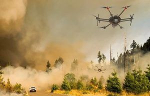
Real-time data ecosystems are essential to react efficiently after a tragedy. Drones equipped with thermal and high-resolution cameras are quickly used to assess hazardous or inaccessible areas. Aerial drones can rapidly inspect large regions, providing real-time videos to rescue teams to help them detect structural hazards or trapped patients.
CCTV cameras installed in cities help track activity, monitor developing crises, and maintain security. Sensor networks placed in flood-prone areas or near chemical facilities allow for quick intervention by identifying dangerous situations such as rising water levels or toxic leaks.
Data collected through surveillance tools, such as video surveillance cameras, serve as the basis for making critical decisions during emergencies. Authorities can use reports on structural stability, flood models, or the progression of wildfires to make decisions on evacuations, resource distribution, and medical assistance.
 For example, by highlighting areas that need immediate attention or indicating obstructed or dangerous routes, surveillance data can help determine the safest evacuation routes.
Advanced analytical systems and artificial intelligence-based systems significantly improve decision-making by predicting disaster courses using real-time data. Thanks to these predictive models, response teams can manage resources more effectively, shorten reaction times, and stop secondary threats such as chemical leaks or landslides.
Multiple entities, including police, firefighters, medical teams, non-governmental organizations, and government authorities, are usually involved in disaster response.
Surveillance systems facilitate collaboration by providing all stakeholders access to a common operational picture. Different teams can coordinate their activities and avoid duplications or gaps in response using data panels and integrated communication systems.
Mobile sensors and environmental monitoring devices can track ongoing risks, such as radiation levels after nuclear incidents, allowing agencies to dynamically adjust their protocols. This level of coordination streamlines efforts and enhances the overall effectiveness of the response.
Despite its numerous advantages, there are several obstacles to overcome when integrating surveillance into disaster response, including:
● Data privacy and ethical issues: tracking affected populations raises concerns about consent and responsible data handling.
● Lack of interoperability: incompatibility between systems of different agencies or jurisdictions can delay information flow and decision-making.
● Infrastructure damage: disasters can disrupt power lines and communication networks, limiting the availability of surveillance data.
● Technological fragmentation: the absence of standardized protocols complicates real-time data exchange during crises.
 Emerging technological advances further amplify the role of surveillance in emergency management. Artificial intelligence and machine learning algorithms analyze large amounts of data to predict disasters more quickly and accurately before they occur. These systems can predict disease outbreaks, flood levels, or wildfire behavior, providing authorities with crucial advance notice to prepare.
Portable sensors and autonomous drones will increasingly assist in post-disaster assessments, allowing for faster damage analysis and victim location. The development of robust, interoperable, and privacy-respecting surveillance infrastructures is essential to fully leverage these innovations. For example, the EU’s Global Flood Awareness System already uses satellite data and hydrological models to predict floods up to 30 days in advance, helping authorities prepare evacuation plans and allocate resources more effectively.
By shifting disaster response from reactive to proactive, surveillance technologies have prevented economic losses and saved many lives. They are essential for contemporary emergency management, as they allow for early hazard identification, provide real-time situation information, and help coordinate response teams.
However, balancing the advantages of technology with ethical issues, data security, and system interoperability remains crucial. Building resilient societies equipped to deal with the challenges of an unpredictable environment will require a careful integration of surveillance into disaster response plans as new advancements occur.

